
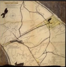
Tashmuit – Map of North Truro
by Shebnah Rich, 25.5″ x 25.5″
$65.00
From the mid-1650’s, an area of land in ‘Pamet’ (Truro) known as ‘Tashmuit’ was settled by the English.
The area was a source of fertile land and fresh springs used by the Paomet people. This 1982 map, composed from 17th century records and later geographical surveys, details North Truro from the bay to the ocean, and also identifies colonial lot owners. Also included on the map is the purported location of the ORIGINAL Pilgrim Springs as documented in Truro Cape Cod or Land Marks and Sea Marks by Shebnah Rich, published in 1883.